
South Africa faces variable weather conditions today, with partly cloudy skies, varying temperatures, and isolated to scattered showers and thundershowers predicted across several provinces. The South African Weather Service (SAWS) has issued several warnings to keep residents alert. This article outlines key weather updates and warnings for each province, helping residents prepare for the days ahead.
Thank you for reading this post, don't forget to subscribe!SEE FULL FORECAST: Today’s Weather Forecast for South Africa – Monday, 8 September 2025
Table of contents
Severe Thunderstorm Warnings in KwaZulu-Natal
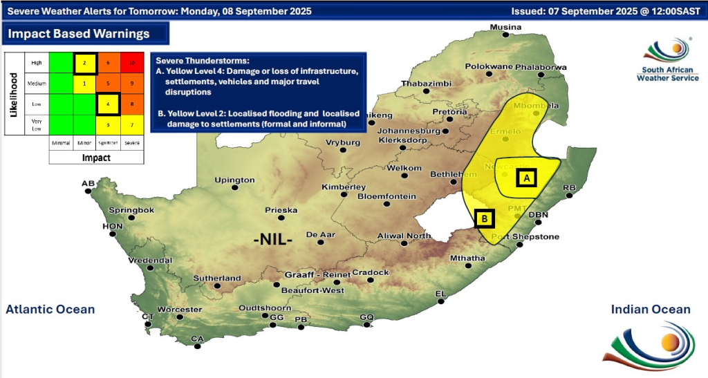
KwaZulu-Natal experiences a Yellow Level 4 severe thunderstorm warning today, with the potential for strong winds, excessive lightning, and hail. This weather system may cause damage to infrastructure, disrupt travel, and affect settlements. Residents in the north-western parts should stay vigilant and avoid unnecessary travel during severe weather periods.
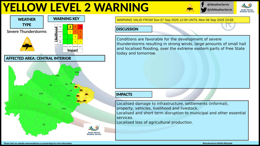
In addition, western KwaZulu-Natal, central and escarpment Mpumalanga, and the extreme eastern Free State hold a Yellow Level 2 warning for severe thunderstorms that may cause localised damage. These areas should prepare for sudden storms accompanied by heavy rain and strong winds.
High Fire Danger Alerts in North West and Northern Cape
The western parts of the North West province and several areas in the Northern Cape face extremely high fire danger conditions. Dry weather combined with windy conditions increases the risk of wildfire outbreaks. Residents and visitors are urged to exercise caution with fire sources and adhere to any fire restrictions in place.
Provincial Weather Updates
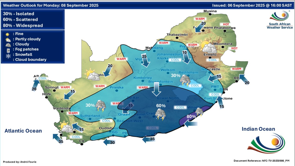
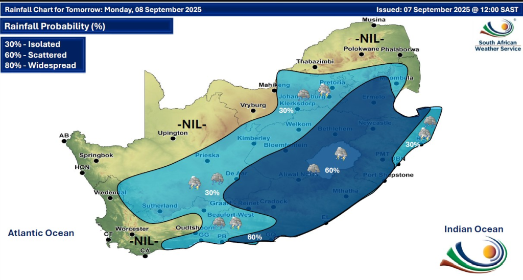
The weather outlook for South Africa on 8 September 2025 is partly cloudy with temperatures ranging from warm to cool across the provinces. Isolated to scattered showers and thundershowers are expected in several regions, especially KwaZulu-Natal, Mpumalanga, and parts of the Free State. Severe thunderstorm warnings with strong winds and lightning are in place, primarily in KwaZulu-Natal. High fire danger alerts exist in parts of North West and Northern Cape due to dry, windy conditions. Residents should stay cautious and keep updated with the latest weather warnings from the South African Weather Service.
Gauteng
Mostly clear to partly cloudy with cool to warm temperatures. Isolated thundershowers may affect eastern and south-eastern parts from the afternoon. UVB sunburn index is high, so sun protection is advised.
Western Cape
Fine conditions prevail in the extreme west. Elsewhere, expect partly cloudy skies with isolated showers and thundershowers in eastern and southeastern areas. Coastal winds shift from moderate southerly to south-westerly in the evening.
KwaZulu-Natal
Mild weather with partly cloudy skies. Isolated to scattered severe thunderstorms are expected, especially in the afternoon, accompanied by strong winds, lightning, and hail.
Eastern Cape
The western half is cloudy with scattered showers and thundershowers, particularly along the coast, while the eastern half sees partly cloudy, mild conditions with similar showers. Fresh easterly to north-easterly winds are expected.
Limpopo
Warm to hot with mild mornings. The region remains mainly dry but localized showers are possible in some areas.
Mpumalanga
Partly cloudy with warm conditions and isolated showers, mainly over the escarpment.
Free State
Cool to warm with isolated showers and thundershowers possible. Winds may become strong in some areas.
North West
Fine, warm days with cool mornings and high fire danger in the west.
Northern Cape
Cool mornings with mild afternoons. Strong winds raise fire risk in some interior parts.
Weather Advisory and Safety Tips
- Residents should remain updated by monitoring SAWS alerts and practice caution around open flames and fire sources, especially in high fire risk areas.
- Avoid outdoor activities during severe thunderstorms, particularly in KwaZulu-Natal and parts of Mpumalanga and Free State.
- Take care while driving during heavy rain or storm conditions, as roads may become slippery or flooded.
- Keep UV protection handy due to moderate to high sunburn indices in several provinces.
Stay Safe
As South Africa experiences a mix of partly cloudy skies, warm to cool temperatures, and scattered showers or thundershowers, it is crucial for residents to stay alert to changing weather conditions. Severe thunderstorm warnings remain in effect for KwaZulu-Natal and surrounding areas, while high fire danger alerts persist in parts of North West and Northern Cape. Staying updated with reliable forecasts and adhering to safety advice can help communities prepare for potential impacts. For the latest warnings and weather updates, always consult the official South African Weather Service and their social media channels.
SAWS recommends staying informed and prepared by regularly checking their official website and social media channels for timely weather warnings and updates.