
South Africa’s weather this Tuesday, 9 September 2025, exerts a dynamic mix of conditions across its nine provinces. The day brings partly cloudy skies with warm to cool temperatures, punctuated by isolated to scattered showers and thundershowers in many regions. Residents and travellers should take note of multiple weather warnings issued by the South African Weather Service (SAWS) to stay safe and prepared.
Thank you for reading this post, don't forget to subscribe!SEE FULL FORECAST: Today’s Weather Forecast for Tuesday, 9 September 2025
Table of contents
- Gauteng: Warm with Isolated Showers
- Mpumalanga: Morning Fog and Isolated Storms
- Limpopo: Warm Southern Areas, Hot in the North
- North West: Windy with Scattered Rain
- Free State: Cool to Warm with Thunderstorms
- Northern Cape: Fog, Wind, and Isolated Showers
- Western Cape: Cool with Fog and Scattered Storms
- Eastern Cape: From Warm Fog to Windy Storms
- KwaZulu-Natal: Partly Cloudy with Severe Thunderstorms
- Severe Weather and Fire Danger Overview
- Stay Safe
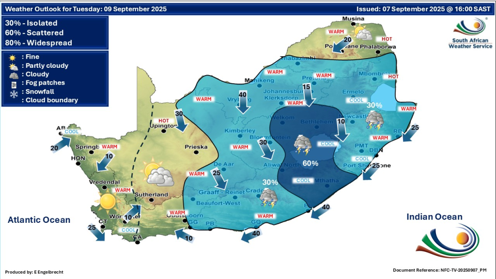
Gauteng: Warm with Isolated Showers
Gauteng will see partly cloudy, warm conditions throughout the day, with isolated showers and thundershowers anticipated. The UVB sunburn index is expected to be very high, so residents should minimise prolonged sun exposure while enjoying outdoor activities. The weather remains mostly dry but with occasional localized rain bursts.
Mpumalanga: Morning Fog and Isolated Storms
Along the escarpment, expect morning fog patches transitioning into partly cloudy skies. The province will experience cool to warm temperatures, with isolated showers and thundershowers mainly in the afternoon and evening.
Limpopo: Warm Southern Areas, Hot in the North
Limpopo’s southern zones remain partly cloudy, while fine and warm conditions will dominate. In contrast, the northern parts of Limpopo see hot temperatures, reflecting the transitioning spring weather.
North West: Windy with Scattered Rain
The North West province turns partly cloudy, windy, and warm. Showers remain isolated generally but become scattered in the southeast late in the day. Residents should prepare for gusty winds which may impact outdoor events.
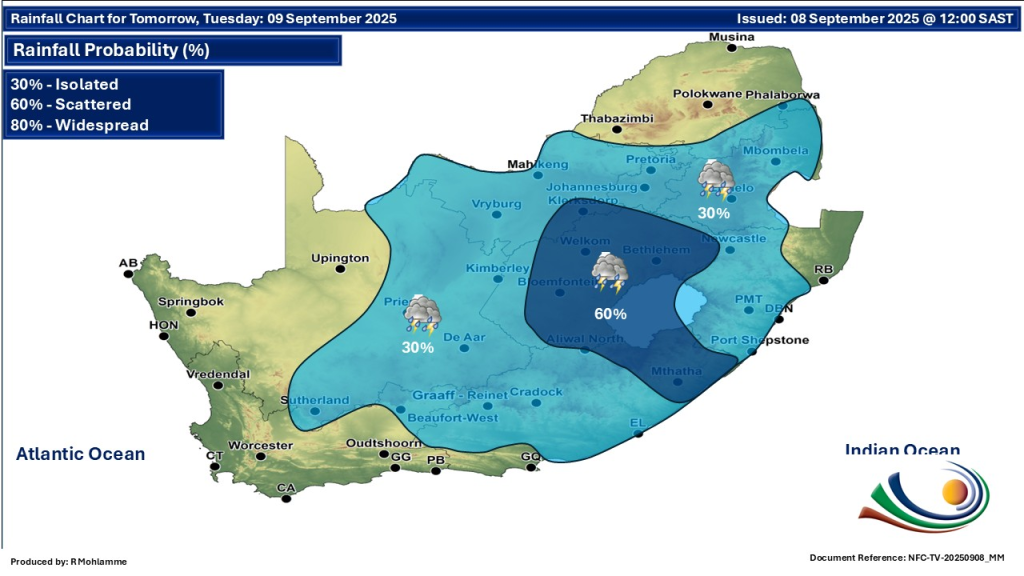
Free State: Cool to Warm with Thunderstorms
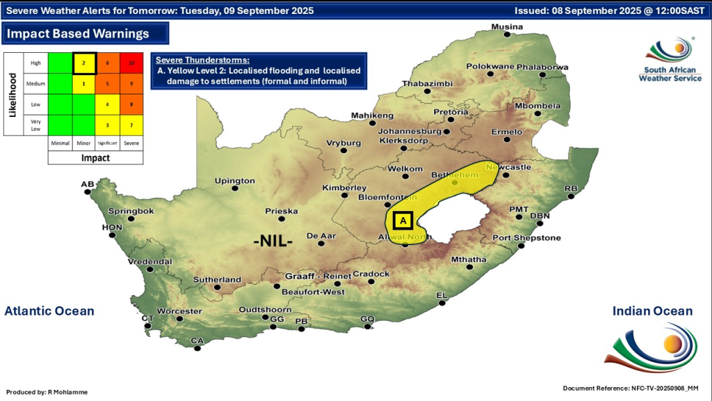
The Free State faces partly cloudy, windy, and cool to warm weather. Scattered showers and thundershowers will affect most areas except for the extreme west, which sees only isolated rainfall. SAWS has issued a yellow level 2 severe thunderstorm warning here, highlighting risks of strong winds, hail, and lightning that could disrupt travel and damage infrastructure.
Northern Cape: Fog, Wind, and Isolated Showers
Morning fog patches linger along the coastal areas. The rest of the Northern Cape experiences partly cloudy, windy, and warm conditions. Isolated showers and thundershowers are expected in the east, while the north-west remains dry. Strong winds could cause minor disruptions, and fire danger remains extremely high, especially in the central and northern parts.
Western Cape: Cool with Fog and Scattered Storms
Morning fog patches occur in places. The Western Cape will be partly cloudy and cool to warm, with isolated showers and thundershowers focused over the province’s north-eastern parts during the afternoon. Coastal winds will be fresh to strong from the east and northeast, raising the risk of rough seas and hazards near the shore.
Eastern Cape: From Warm Fog to Windy Storms
In the western half, morning fog sets the scene before partly cloudy skies emerge. This part of the province will be warm to hot with isolated thundershowers in the northern and eastern sections. The eastern half faces cloudy, windy, and warm conditions with showers and thundershowers scattered mostly in the east. Moderate to fresh easterly winds will affect the coastline, making for potentially choppy sea conditions.
KwaZulu-Natal: Partly Cloudy with Severe Thunderstorms
KwaZulu-Natal experiences partly cloudy, warm conditions with cooler weather in the southwest. Isolated showers and thundershowers occur, except in the northeast. SAWS has issued a yellow level 2 warning for severe thunderstorms in the north-western parts, with risks of strong winds, lightning, and hail that could cause damage and travel disruption.
Severe Weather and Fire Danger Overview
- Severe thunderstorm warnings (yellow level 2) apply to parts of the Free State, KwaZulu-Natal, and Eastern Cape, highlighting the potential for damaging winds, hail, and lightning causing infrastructure and travel disruptions.
- Fire danger warnings remain high. Central and northern parts of South Africa face extremely high fire danger conditions, requiring heightened precautions amid windy conditions.
- No heatwave or snowfall warnings are currently in effect, but the mix of winds, storms, and fire risks requires vigilance.
Tips for Staying Safe
- Avoid outdoor activities during severe thunderstorms and heed weather alerts promptly.
- Protect against sunburn with sunscreen and appropriate clothing in areas of high UV index like Gauteng.
- Be cautious of fog in the early mornings, especially on roads and highways.
- Keep updated on fire risk warnings, especially in fire-prone parts of Northern Cape, to prevent wildfires.
Stay Safe
South Africa faces an active weather week, shifting between warm sunshine, scattered rains, and storm risks. The changing springtime conditions bring opportunity for sun and showers alike, reminding all to prepare and stay weather-wise.
For timely updates and accurate forecasts, always check the official South African Weather Service website and follow their X/Twitter page (@SAWeatherServic).