
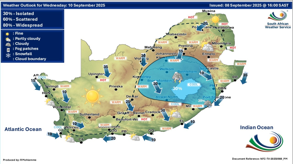
South Africa faces a day of varied weather on Wednesday, 10 September 2025. Most provinces will experience a mix of partly cloudy skies, windy conditions, and temperatures ranging from cool to warm. Isolated to scattered showers and thundershowers are expected across several regions, bringing a touch of winter chill alongside the warmer spots.
Thank you for reading this post, don't forget to subscribe!SEE FULL FORECAST: Today’s Weather Forecast for 10/09/2025
Table of contents
Key Weather Warnings for South Africa
- Fire Danger: Extremely high fire danger warnings are active over parts of the Free State, North West, Northern Cape, Eastern Cape, Gauteng, Mpumalanga, Limpopo, and KwaZulu-Natal. These conditions result from prolonged dry and windy weather, increasing the risk of wildfires. Residents in these areas must avoid open flames and ensure safe fire management.
- Severe Thunderstorms: Yellow Level 2 impact-based warnings cover severe thunderstorms with strong winds, lightning, and hail in the eastern and south-eastern Free State, parts of KwaZulu-Natal, and the eastern Eastern Cape. These storms may cause localised damage to infrastructure, disrupt transportation, and affect outdoor activities.
- Fog: Morning fog patches will occur in parts of the Northern Cape, Western Cape, and the Lowveld of Mpumalanga. Drivers and commuters are advised to exercise caution when visibility is reduced, especially on rural or less illuminated roads.
- Wind: Windy conditions prevail in many provinces, notably Gauteng, Northern Cape, Free State, and coastal areas of the Western Cape. These winds can exacerbate fire risks and cause minor disturbances outside.
- No cold front or snow: There are no severe cold fronts or snowfall expected in South Africa at this time.
Provincial Weather Warnings and Updates
Gauteng
Gauteng is partly cloudy and warm with isolated showers and thundershowers possible. Winds will increase in strength, raising fire danger conditions to extremely high. Residents should be vigilant and avoid activities that could trigger fires.
Free State
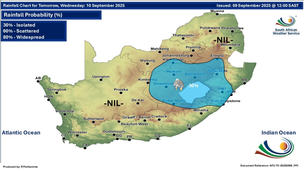
Windy, cool to warm, with scattered showers and thundershowers expected across much of the province. Fire warnings remain high, especially in the western areas. Thunderstorms could bring strong gusts and lightning that raise safety concerns.
KwaZulu-Natal
Warmest in the country, KwaZulu-Natal sees windy conditions with isolated to scattered showers and thundershowers. Northern areas particularly face the risk of more intense storms. Fire danger remains elevated due to dry, gusty winds.
Northern Cape
Morning fog dominates coastal areas, but the interior will be partly cloudy, windy, and warm. Isolated showers and thundershowers may occur in the east, while fire danger warnings remain at critical levels in central and northern parts.
Eastern Cape
A divided picture: the western half is partly cloudy with warm to hot temperatures and isolated thundershowers. The eastern half is cloudy, windy, and warm with scattered showers. Fire warnings apply mainly to local municipalities in the northeast.
Limpopo
Mostly fine and warm, though the north northeastern regions will experience very hot conditions. Windy days continue to feed fire risk warnings that affect most parts of the province.
Mpumalanga
Cool to warm with morning fog patches along the escarpment. Isolated showers and thundershowers will develop, mainly over the Highveld. Fire danger warnings are in place due to persistent dry, windy conditions.
North West
Partly cloudy, windy, and warm with isolated showers scattered in the southeast. Like other central provinces, fire danger levels are extremely high, urging caution with open fire and outdoor activities.
Western Cape
Morning fog patches, followed by partly cloudy and cool to warm temperatures. Isolated showers and thundershowers are possible in northeastern areas during the afternoon. Winds will be fresh to strong along the coast, complicating fire risk management.
What You Need to Know Today and This Week
South Africa is facing a critical fire danger period thanks to dry, hot, and windy weather conditions spanning several provinces. This warrants extreme caution especially in rural and grassland areas. The threat of severe thunderstorms with hail and strong winds primarily in the east and southeast also poses safety risks.
Foggy morning conditions in coastal and low-lying regions demand attention for road safety, while wind alerts could impact coastal and inland areas alike. Residents are advised to stay informed through trusted sources like the South African Weather Service and limit exposure to outdoor hazards wherever possible.
Stay Prepared
South Africans are encouraged to prepare for potentially volatile weather conditions this week:
- Monitor official weather updates closely through SAWS websites and social media channels.
- Exercise caution during outdoor activities, especially in areas with fire warnings.
- Drivers should be extra cautious in fog-prone areas during early mornings and late evenings.
- Ensure all fires are extinguished fully and avoid burning in high-risk zones.
- Be aware of sudden storm development and seek shelter when thunderstorms approach.
For the most accurate and timely updates throughout the week, always check the official South African Weather Service (SAWS) website and their X/Twitter page. Staying informed is crucial for safety and well-being during this unsettled weather period.